After getting denied a salt permit for 3 straight years, I decided to stop waiting for better luck and just run it in February. Things were looking up when the river spiked to 4000 cfs on January 28, but I was unable to make the trip for 2 weeks, and by then flows were heading below 250. The general consensus among my friends was 300 is the minimum runnable flow. Fast forward 2 weeks, and Dave and I found ourselves at the put in on Friday morning with 225 cfs slowly drifting by. The weather was 50 and sunny, so we shoved off with fully loaded boats and began bumping our way down the river.

Based on NOAA’s flow forecast, we expected to get a surge to 400+ cfs on Saturday, and ride this “high water” for the remainder of our trip. With this bit of good news, we decided to go for it. A fact that I already knew but overlooked because I really wanted to go boating: NOAA is less than perfect at forecasting flows. Oddly enough, we were glad that they blew their estimate. Had we known that flows would hover between 205 and 235 cfs, we would have bailed on the trip and gone skiing instead. And everybody knows kayaking the mank is way more fun than skiing!
Side note: Raft companies weren’t running shuttle yet, so we ended up using the Rock House Grocery Station PH: 928-467-2484. Shuttle was $85. They did a good job and stored our car at their house until our takeout day, which lessened the chance of vandalism at the boat ramp.
 |
| Overlooking the upper canyon |
Having never run the river before and not spending much time internet scouting except to print off a few maps (great map: http://www.inaraft.com/pdf/maps/salt-river-map-satellite.pdf) we didn’t know what to expect. For the first 13 miles or so, the scenery was pretty typical of a desert canyon with huge sandstone cliffs rising up on both sides.


About the same time we spotted our first saguaro cactus we saw a roadrunner peering at us from the bank. This is exactly what I was expecting to experience on the Salt. Mile 10 provided a unique section called the Salt Banks which give the river its name.
 |
| The Salt Banks |
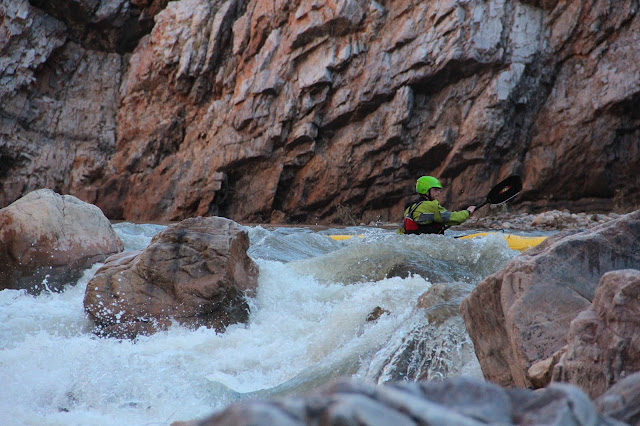
Sometime around mile 13 the sandstone gave way to a narrow gorge lined with white granite boulders. This was one of the most beautiful sections of the trip, and provided some fun II-III rapids to make the miles fly by.
 |
| Entering the White Granite Gorge |
7 hours after launching we had covered 18 miles. As the gorge started to open up into Gleason Flats we found a great campsite on river left with a big sandy beach. One of the few perks to ELFing was that we were probably the only people in the canyon, and didn't have any competition for the best camping spots. With the exception of a group in a pickup early on day one, we didn't see anyone in the canyon the entire trip.
Day two started out with a nice tail wind, but the shallow water in Gleason Flats quickly slowed our progress. While we never got out of our boats to portage, there were a number of spots every day that required hand crawling across shallow, braided sections. After an hour and a half of bumping and grinding, we made it out of the flats and back into the rapids. Black Rock (IV) was the most difficult rapid of our trip at these flows. The left channel was dry so we easily hiked back up and each ran a few laps before continuing on.
 |
| Black Rock |
 |
| Black Rock |
 |
| Black Rock |
We continued down through a 2nd narrow gorge, this time with black granite boulders. This was another fun, busy stretch of rapids with plenty of water to be enjoyable.
About a mile beneath The Maze the canyon hangs a hard right and again changes character as it enters Jumpoff Canyon. While only about a mile long, this was my favorite stretch of the river.
 |
| Entering Jumpoff Canyon |
Based on Quartzite’s reputation, we got out to scout and take photos. Not seeing much of a rapid, we decided we must have stopped too early, and only after reaching Corkscrew did we realize we had boated through Quartzite. Corkscrew (IV) was the 2nd hardest rapid following Black Rock. The left chute was the less manky option and lined us up nicely to finish the 2nd drop.
 |
| Corkscrew |
 |
| Dave lining up for the left chute |
 |
| Corkscrew |
 |
| Left Slot |
We paddled the last 4 miles of mostly flat water before making camp at the mouth of Cherry Creek. We found some ruins overlooking the river, had a night hike up the creek with a full moon, and even had some Javelinas walk into camp.
 |
| Cherry Creek confluence |
Cherry Creek is an amazing place, and I wish our schedule had allowed a layover day to hike up the canyon. Because it is fed by several springs, the ecosystem is entirely different from most of the surrounding canyons. Saguaros and prickly pear are replaced with cottonwood and sycamore trees, and the scenery gets even better several miles upstream of the confluence with the Salt. One last thing about Cherry Creek is that the water is free of silt and tastes much better than the water from the river if you are only using a steripen or iodine for purification.
Sometime Saturday night I woke up to rain hitting me in the face. I crawled in the tent, and when we crawled back out in the morning there was fresh snow on the mountains. The weather alternated between snow, sleet, and rain for the next hour before the sun finally came out and stayed out for the rest of the trip.
 |
| The last of the snow melting as the sun breaks through |
 |
| Day 3, with snow on the distant peaks |
 |
| Bald Eagle |
The paddle out on Sunday proved to be pretty challenging, with flows barley above 200 cfs and a strong headwind developing around noon. 50 miles of boat abuse finally caught up with us, and I developed a leak in the bottom of my boat. The last 10 miles felt like we were in a bird sanctuary with reeds and grasses covering the banks. It was a beautiful day with sunshine, warm temps, and sightings of Bald Eagle, Raccoon, Mallard, Teal, Coot, Crane, and Cormorant. As with the upper and middle canyons which had white and black granite gorges, the lower canyon had a similar gorge of pink granite. Just before we reached the takeout, the river went through one last gorged section with several goosenecks before opening up literally right above the boat ramp.
Considering the low flow, two questions I wanted to answer are 1) am I glad we went, and 2) would I do it again at the same level? I am definitely glad we made the trip. The salt is one of the most amazing canyons I have paddled. More water would have been nice, but the scenery and the experience was magnificent regardless of the flows. Would I do it again at 225 cfs? Nope. Cheers, John.
Good work buddy! Be home soon for some more goods. Praying for snow!
ReplyDelete